


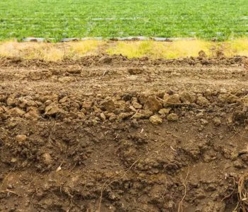
Soil, this thin layer on the Earth’s surface composed of inorganic and organic substances, is the primary natural resource for the production of food, fibers, and bioenergy, while also playing a crucial role in ecosystems and global climate regulation. It consists of various solid (mineral, organic), liquid, and gaseous components, which interact with each other and the external environment.
Beyond supporting production, soil also provides environmental services such as carbon storage, nutrient cycling, water infiltration and retention, and biodiversity shelter. Soils are naturally heterogeneous due to significant variations in factors like parent material (rocks), landscape (topography), climate, weathering (the natural process of rock breakdown and alteration), and biological activity.
These differences are reflected in the physical, chemical, and biological properties of the soil, which can vary due to the complex interactions of several factors, including biological (earthworms, microorganisms, ants), edaphic (texture, structure, organic matter, nutrients), anthropogenic (human activity), topographic (slope, lowlands, or elevations), and climatic (temperature, humidity, precipitation).
Soil characteristics can vary spatially, even within the same field or paddock, extending to a regional scale. These variations may arise from soil formation factors or from management practices, fertilization, and crop rotation.
The Irish physicist William Thomson stated that “what cannot be measured, cannot be improved,” emphasizing that soil property variations must be monitored and quantified to understand the effects of land use and management systems.
These applications have driven the development of sensors to measure soil properties, complementing or even replacing conventional laboratory techniques used for soil analysis.
New technologies serve as valuable tools to enhance knowledge in soil science disciplines:
- Pedology, which studies the origin, evolution, and classification of soil as a natural component of the landscape.
- Edaphology, which examines soil’s influence on living organisms.
Three main approaches can be highlighted for soil monitoring:
- The first, and most traditional, uses conventional methods based on sample collection and laboratory measurements.
- The second utilizes remote sensing, with images from aerial vehicles and satellites.
- The third involves proximal sensing, which provides detailed data from closer distances.
Currently, the traditional method involves soil sampling in the field followed by laboratory analysis in various segmented work stages. The overall process of soil sampling and analysis follows these steps: planning and sampling, sample preparation, soil analysis, data management, interpretation, and recommendation.
Generally, the methods used by traditional laboratories, which involve chemicals, are more time-consuming, have environmental impact, and can be costly.
Remote sensing techniques offer several advantages over other methods of measuring soil properties, including:
- Large-scale coverage
- Non-destructive nature
- The ability for temporal monitoring
- The capture of different light spectra
- Rapid data acquisition
Soil analysis based on images and sensors offers several advantages over conventional laboratory methods, such as lower cost, higher efficiency, faster results, and the ability to collect large datasets.
But what is the best technology for soil monitoring? The most efficient approach will depend on the objective, but a combination of remote and proximal sensors, along with laboratory methods, can be advantageous. Therefore, the choice of method depends on the specific measurement being sought.
A single sensor often does not provide enough information to reliably predict various soil properties. Therefore, data fusion from different sensors, measuring different properties, can increase prediction accuracy.
The future trend in soil monitoring points to the use of high-resolution images and sensors, combined with more localized and specific laboratory determinations.
The real-time analysis and processing of information can enhance the accuracy, precision, and speed of diagnostics. To achieve this, new digital technologies will be essential.
We have seen that emerging technologies, many of which result from research, large companies, and AgTechs (startups in agriculture), are promoting data-driven innovation that improves strategic decision-making. The growing need for soil monitoring is driving innovations in methods, sensors, and equipment.
Digital technologies such as the Internet of Things (IoT), combining sensors, robots, and UAVs (Unmanned Aerial Vehicles) with artificial intelligence (AI) software, blockchain, virtual reality, and augmented reality, are driving the rapid advancement of management information systems in agriculture. These technologies have significant potential for use in soil monitoring and management.
There are IoT-enabled sensors that collect, analyze, and transmit real-time data on parameters such as temperature, humidity, electrical conductivity, and nutrient concentration. Robotics is also expected to impact soil monitoring by enabling more precise and efficient sampling and analysis, while reducing effort and increasing work capacity.
Data analysis, including signal processing, sampling, and calibration, is advancing with artificial intelligence, encompassing machine learning, modeling, and data fusion from multiple sensors.
Techniques for digital soil mapping, applying artificial intelligence, have also progressed, relating geographically referenced data from field and laboratory measurements, along with environmental data. These maps provide insights into the spatial variability of soil properties in a given area, identifying potential degradation risks such as erosion, nutrient depletion, and compaction.
There are also immersive technologies, such as virtual reality (VR) and augmented reality (AR), which can contribute to improving the efficiency and accuracy of soil data collection and analysis.
With VR, it will be possible to create realistic simulations of different production environments, allowing technicians and farmers to test and evaluate management practices.
AR will enable the overlay of information about soil conditions, crop growth, and other landscape and climate data. This presents an opportunity for technicians and farmers to easily identify areas that may need attention, such as critical pest infestation points or nutrient deficiencies.
Finally, blockchain can bring security and transparency to the data collected by soil sensors, as well as enable the tracking of various equipment and inputs in the supply chain. The data collected is stored in a decentralized, tamper-proof manner, ensuring data security and improving transparency and traceability for farmers and landowners.
The Food and Agriculture Organization (FAO) has designated December 5th as World Soil Day. This date serves as a reminder of the importance of this natural resource in our lives. This year’s theme highlights the importance of data and information to understand soil and support better decisions for sustainable management, food security, and environmental services.
Moreover, well-managed soil is key to achieving several Sustainable Development Goals (SDGs), such as those related to hunger reduction (SDG 2), extreme poverty (SDGs 1, 3), and the improvement of environmental protection (SDGs 6, 11, 12, 14, 15) and global climate (SDG 13).
Read the original content in Portuguese at nutriNews Brasil.
By: Alberto C. de Campos Bernardi
Source: Embrapa